This map shows the military positions and other points of interest of the Rif War (1909-1927). It’s a historical resource designed to help researchers, students and other persons interested in following the campaigns of the Rif War.
A Map of Spain’s Rif War in Morocco
by Jesús Dapena
(email: dapena@iu.edu)
(Para ver esta página de web en ESPAÑOL, vete AQUÍ.)
Quickstart
How to download and see the map
To download the map, make a right-click HERE. Follow that with a left- or right-click on “Download Linked File As …”. This saves the map pdf file to your computer. You can then open the downloaded file with Adobe Acrobat Reader. It’s a free program you can download through internet. (NOTE: Don’t open the map pdf directly on the browser using a left-click, because that could lead to problems. For instance, you may not be able to magnify the image enough to see the map properly.) You can increase or decrease the scale of the map image using the magnifying glass icons at the lower right corner of the Adobe Acrobat Reader window. (After downloading the map pdf file, you can also open it with Adobe Illustrator. But this is an expensive program; if you don’t already have it, you are better off using Adobe Acrobat Reader.)
To see the map on your iPhone, you will need to have Adobe Acrobat Reader (or “Acrobat”) installed. You can download this program to your iPhone from the Apple Store; I believe it is also free. Download the map file from the browser to the Files folder of your iPhone (“Save to Files”). Then go to your Files folder, and tap on the map’s icon to open it. Select “Open in Acrobat” from the bottom of your iPhone’s window. This will allow you to view the map. Another way to view the map after saving it to the Files folder is to turn on the Adobe Acrobat Reader (“Acrobat”) app, and then select the map file from the app.
Searching for places
The Adobe programs allow you also to search for place names. This is a crucial feature of the map. (See below.) But the spelling that you use (the one taken from whatever book or article you are reading) may be different from the one used by the map. This is very common, and in such cases, you will obviously have a problem.
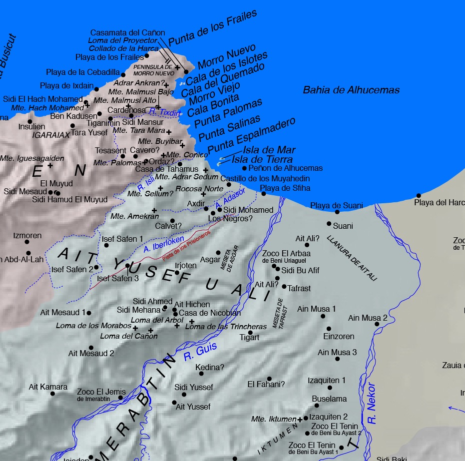
Sample of a small section of the map
Detailed information
The project
Two problems in the existing maps:
I have always had difficulty finding appropriate maps for Spain’s 1909-1927 Rif War. There are two problems that often occur in the maps published in the literature of this war: (1) inaccurate locations of places, and (2) spelling inconsistencies of place names.
The origin of the problems was that much of the area had not been properly surveyed before the war. The very border between the Spanish and French sectors of Morocco was to a great extent a fantasy. It was a line drawn on a map that was meaningless in many areas. It is not surprising that the Spanish and the French kept squabbling about where the border should be. Both rushed to occupy areas and produce a “fait accompli”. (I will discuss the border further below.)
I assume that when the Spanish entered a new area, they obtained geographical names verbally from the locals. Then they transcribed them into Spanish as best they could, and made rough map sketches (“croquis”). The Spanish Army then used those map sketches and place names, as did the journalists reporting on the war. Different people heard the local sounds differently. Therefore, it was normal to end up with several different spellings for the name of any single location. An extreme example is Sbu Sba/Sbu Sbaa/Sebu Sbaa/Buch Sbaa/Sbuch Sba/Sbuch Sbaa/Sbuch Sbach/Sbuh Sbah/Sebbux Es Sebaa/Sebuch Sbaa/Sebouch Sbaa/Zebbuya Es Sebaa/Zebbuy Sebaa/Zebbuy Sebas/Acebuche del Leon.
This ultimately resulted in maps that were inaccurate, and place names that varied from one map and publication to another. These problems have trickled down to many of today’s publications.
Goal of this project:
The goal of this project was to produce a better map for readers interested in following the war’s military operations.
Methods
Base maps:
My map is based mainly on three sets of previous maps:
(1) A shaded relief greyscale map of northern Morocco in the Web Mercator projection. It was produced using SRTM data obtained from the Space Shuttle with radar technology. Tom Patterson of shadedrelief.com kindly provided it to me.
(2) A selection of 109 tiles of the 1:50,000 scale topographic “Carte du Maroc” published by the Institut Géographique National (Paris) and by the Division de la Carte (Rabat), mostly in the late 1960s and early 1970s. They cover the former Spanish Protectorate of Morocco and the north end of the former French Protectorate. I found these excellent maps in the website of Dr. Rachid Bissour of Sultan Moulay Slimane University at Beni Mellal. That website later stopped working, but these maps –as well as other topo maps of Morocco– can be obtained HERE.
(3) The 117 tiles of the 1:50,000 scale topographic “Mapa Provisional (del Norte de Marruecos)” published by the Spanish Army. They cover the former Spanish Protectorate of Morocco. I looked for the most recent version of each tile. One from between 1956 and 1959 was available for almost every tile. As already suggested by the term “provisional”, these Spanish maps were plotted with less accuracy than the French/Moroccan topo maps. However, they show the kabila borders, as well as richer detail in village, mountain and river names. You can download the individual maps from HERE. You need to enter in the “Search” or “Búsqueda” box the name of one of the various regions of the Spanish zone of Morocco (Utauien, Yebala, Gomara, Ketama, Rif, or Kelaia). This search will give you many more maps than those in which you are interested; you will need to select the appropriate ones for download.
Additional maps:
I also occasionally used information taken from the 14 tiles of the 1:100,000 scale “Mapa del Norte de Marruecos”. The Spanish Army published these maps between 1943 and 1947. They showed reasonable consistency with the “Mapa Provisional (del Norte de Marruecos)”. The 1918 1:100,000 scale “Mapa Militar” of the eastern war zone (5 tiles) is also surprisingly good considering its early date. The corresponding map for the western war zone (1922/1924, 1 tile, 1:150,000 scale) is much less accurate, although still useful.
You can download the 1:100,000 scale “Mapa del Norte de Marruecos” and 1:150,000 scale “Mapa Militar” (western war zone) from the same website as the 1:50,000 scale Spanish Army maps by entering in the “Search” or “Búsqueda” box the strings “Norte de Marruecos” and “Mapa Militar Marruecos”, respectively. Again, you will need to select the appropriate maps for download. You can download the “Mapa Militar” (eastern war zone) from HERE; click on “Ver obra”.
Construction of the map:
I started by trimming the frames out of the 109 French/Moroccan topo maps, leaving only the true map area. Then with Adobe Illustrator I combined the individual tiles into a large mosaic. In this mosaic, I marked the positions of the places of interest, and traced the rivers and the coastline. To correct for the differences in cartographical projection between the mosaic and the shaded relief map, I also marked in both maps the locations of several hundred calibration landmarks (mainly hill and mountain peaks). Then I used Adobe Illustrator to construct a mesh consisting of the four corners of all the tiles. I distorted this mesh to fit the calibration landmarks of the mosaic to their locations in the shaded relief map. I then applied the same distortions to the places of interest, the rivers, and the coastline. Finally, I superimposed their positions on the shaded relief map.
The Spanish Army topo maps added the kabila borders and points of interest absent from the French/Moroccan topo maps.
The border between the Spanish and French zones:
The border between the Spanish and French zones presented a series of problems. At first, I assumed that the ragged bottom edge of the Spanish Army topo maps represented the border. However, I later realized that it generally marked only the limit of the area surveyed by the Spanish Army. This border was ill-defined in the various treaties and agreements between the Spanish and French governments. It also did not remain stationary, but generally crept northward in the course of the war. The Spanish and French governments often did not agree where the border was supposed to be.
I found in Internet several Spanish maps that showed the border at various dates. However, they were only rough and inaccurate sketches (“croquis”), usually drawn at small scales. (To see some of these maps, go HERE, and enter the string “trazado fronterizo” in the “Search” or “Búsqueda” box.) The most detailed depiction of the border that I found in Internet was, surprisingly, in a map produced by the United States Army in 1953. It’s available HERE. It’s the 7th map in that web page, “Cartes 1 / 250 000 (U.S. Army 1953)”. It was based on earlier Spanish and French maps. The border of my map generally follows this American map from 1953. It should be considered a reasonable but definitely imperfect representation of the position(s) of the border during the war.
Using the map
How to download and see the map:
Searching for places:
When making searches, keep in mind that some place names take up two lines of text. This is standard for all the marketplaces (zocos). For instance, Zoco El Telata de Azilaf consists of a first line saying “Zoco El Telata” and a second line saying “de Azilaf”. So a search for “Zoco El Telata de Azilaf” will produce no hits; you will need to search separately for “Zoco El Telata” or for “de Azilaf”.
The places without question marks after their names in the map are quite solid. They are points I was able to locate in the trustworthy maps described above. The places with question marks are more doubtful. I took their approximate locations from maps in the literature. This allows us to know which place locations to believe and which ones are only approximations.
It’s common to find some place names repeated in widely separated areas of the map. But sometimes the topo maps show the same place name repeated within a rather small area. I assumed that this meant that a village was spread out, and that the map simply repeated the village name at the various locations of the village’s house clusters. In these cases, I added an arbitrary number (1, 2, 3, …) after the place name. This was to make the reader aware that this name occurred more than once within a small area.
Alternative place names:
As I mentioned before, you can search for place names on the map with your computer. Open the map’s pdf file with Adobe Acrobat Reader, and type the name of any place. The app will find it in the map. However, if the spelling that you use (taken from whatever publication you are reading) is different from the one in the map, you will obviously have a problem.
To solve this problem, I put together an extensive glossary of alternative place names. The name before the equal sign is an alternative name. The name after the equal sign is the one that the map uses. You should first search in the map using the spelling from the publication you are reading. If you don’t get any hits, search in the glossary. Then try on the map the spelling that shows up after the equal sign.
Language:
I believe that most of the literature on this war is in Spanish. Therefore, I chose to make Spanish the basic language for the map. Also, I used for each place name the spelling that appeared to occur most commonly in the Spanish literature. This was not necessarily the most correct version of the name. For instance, “Zoco Es Sebt” (or even better, “Suk Es Sebt” or “Souk Es Sebt”) is the correct transliteration from Arabic of “Saturday Market”, but in the map I used “Zoco El Sebt”, which is the version that I found most frequently in the Spanish literature.
Accents:
I have not used accent marks in the map nor in the glossary. This was for two reasons. The first one is that many publications omit the accents, or put them in an incorrect position. Therefore, using accent marks would be an additional hurdle for finding place names. The second reason is that in most cases I also don’t know where the accent should go!
I will continue making modifications to the map and adding alternative names to the glossary as new information becomes available.
If there is a place that you can’t find, please feel free to send me an email to dapena@iu.edu. I will try to help you to find it.
Translation of some geographical terms:
Finally, I made a listing of Moroccan geographical terms and their translations into Spanish and English. I took most of these terms from Gabriel Delbrel (pages 165-178) and from Francisco Martínez Yagües (pages 567-570).
Scale:
There is a 10 km scale at the lower right corner of the map. It may also be useful to know that the diameter of each small black dot on the map corresponds to 200 meters in real life, while the diameter of the larger black dots of the main towns corresponds to 500 meters in real life.
Printed version of the map
If you would prefer to have a hard copy of the map, you can purchase one from Amazon.com or Amazon.es. At the Amazon website, you can find it with a search for one of the following strings: “mapa guerra marruecos”, or “Jesus Dapena”.
Please contact me (dapena@iu.edu) with any errors that you see in the map or in the glossary. Thank you!